top of page

[ ARCHAELOGICAL TERRITORIES ]


_17_12_2023_ESPA.jpg)
Design strategies for the formulation of temporal scenarios, a method applied to archaeological territories in Latin America. The cases include: Governor's Island in Guanabara Bay in Rio de Janeiro - Brazil, the City of Arica and Parinacota region in Chile, the City of Cachipay, La Mesa, and Anapoima in Colombia, the Copan Ruins in Honduras, the Iximché Ruins in Guatemala, and Uxmal and Xkalupocoh / Nohpat in the Puuc region of the Yucatán Peninsula in Mexico.
Presentation:
The research presents itself as a possibility for archaeological zones, exploring their spatial and territorial relationships, and their influences on macro and micro geography, being led towards improvement through their historical monumentality and impacts on adjoining areas. This enables the fostering of strategies that promote the "Sustainable Development Goals," facilitating new characteristics in territorial approach processes through the emergence of new models of spaces and infrastructures.
The selection of this theme is based on the historical importance and the influence of archaeological territories in Latin America, the geographical impacts, and their relationship between coastal areas, settlements, human settlements, and villages which lack interconnections. Despite being characterized as historical poles, they do not show economic or social development and are plagued by various problems throughout the 20th century.
The model allows for the expansion of capabilities in professional training and understanding, spatial comprehension, and morphological readings of archaeological zones through strategic planning, as potentials for the development of qualified human appropriations in their immediate surroundings and the formulation of territorial indicators present in historical sectors. The focus is established in areas where the archaeological and geographical relationship presents spatial qualities regarding the so-called built spaces that currently relate in areas with potential for regional development.
The research aims to apply strategies that enable the development of future project scenarios for territorial development, whose studies allow spatial and urban approaches of archaeological territories in Latin America. It promotes and fosters articulated networks between territorial characteristics present at the boundaries of archaeological territories, alongside geographies, new forms of urban appropriation, and support in the macro and microterritory through the application of methodological tools supported by spatial restructuring. This expands the capacity in edge zones through strategies that foster territorial improvement, formulating prospective and temporal scenarios of local development.
aos denominados espaços construídos que se relacionam na atualidade em áreas potenciais para desenvolvimento regional. A pesquisa tem como objetivo aplicar

.png)

estratégias que possibilitem desenvolver cenários projetuais futuros de desenvolvimento territorial, cujos estudos possibilitam abordagens espaciais e urbanas dos territórios arqueológicos na América Latina. Promovendo e fomentando redes articuladas entre características territoriais presentes nos limites dos territórios arqueológicos, junto a geografias, a novas formas de apropriação urbana e suporte no macro e microterritório por meio da aplicação de ferramentas metodológicas apoiadas na reestruturação espacial. Ampliando a capacidade nas zonas de borda por meio de estratégias que fomentem a melhoria territorial, formulando cenários prospectivos e temporais de desenvolvimento local.


CARTAS CONVITE


DIÁLOGOS E PALESTRAS

%2011_06_42_e4d3e6bc.jpg)
%2013_28_12_3301aa10.jpg)
JUNHO 2024
PRIMER FORO - ESTRATEGIAS PROYECTUALES EN TERRITORIOS ARQUEOLÓGICOS

JULHO 2024
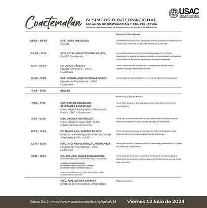
IV SIMPOSIO DE INVESTIGACIONES DIFA, 500 AÑOS DE DESTRUCCIÓN Y CONSTRUCCIÓN
.jpeg)


.jpeg)
VÍDEO

TRANSMISSÃO DIA 11/07
VÍDEO
TRANSMISSÃO DIA 12/07
LOS CENTROS HISTÓRICOS EN EL CONTEXTO DE LAS DINÁMICAS URBANAS CONTEMPORÁNEAS. GESTIÓN Y PUESTA EN VALOR. MÉRIDA Y SUS PROCESOS DE URBANIZACIÓM
MAIO 2024


ESTRATEGIAS PROYECTUALES EN TERRITORIOS ARQUEOLÓGICOS EN AMÉRICA LATINA
AGOSTO 2024


WORKSHOPS - RIO DE JANEIRO, HONDURAS AND GUATEMALA

Copán Ruínas, Honduras

Kaminaljuýu,
Guatemala
WORKSHOPS - RIO DE JANEIRO, HONDURAS AND GUATEMALA
%2011_06_42_4d290c2d.jpg)
México


Programação Rio de Janeiro
Programação Honduras
Programação Guatemala
EXPOSIÇÕES
YUCATÁN, MÉXICO
_page-0001.jpg)
_page-0001.jpg)
_removed_page-0001.jpg)
REGISTROS DE EVENTOS DE EXTENSÃO UNIVERSITÁRIA

Honduras

Guatemala

Rio de Janeiro

Rio de Janeiro
GOVERNOR'S ISLAND, IN GUANABARA'S BAY IN RIO DE JANEIRO - BRAZIL

.png)

This archaeological zone, due to its proximity to a consolidated territory and following the disaster at the National Museum in Rio, stands as a real hypothesis to establish new parameters for scientific production in terms of recognition, mapping, structuring, and territorial rearrangement, and methods for analyzing territories stemming from early human occupations on the continent.
Structurally, the territory is characterized by a perimeter that is significantly urbanized, which in remote periods was used by a population of hunter-gatherers, giving rise to the Sambaqui zones present in Brazilian territories. It is crucial to note that the archaeological territory includes 10 archaeological sites, forming zones of villages, occupying regions near the maritime edge.
![[ARQUEOLOGIA] Prancha X - Ilha do Governador_page-0001.jpg](https://static.wixstatic.com/media/4bd3d7_4108a30eb96f4808a32863a53cffc5c5~mv2.jpg/v1/fill/w_353,h_500,al_c,q_80,usm_0.66_1.00_0.01,enc_avif,quality_auto/%5BARQUEOLOGIA%5D%20Prancha%20X%20-%20Ilha%20do%20Governador_page-0001.jpg)
Estruturalmente o território se caracteriza por um perímetro significativamente urbanizado, que em períodos remotos fora utilizado por população formada por caçadorescoletores, dando origem as zonas de Sambaquis presentes nos territórios brasileiros. É fundamental apontar que o território arqueológico consta com 10 sítios arqueológicos, conformando zonas de aldeias, ocupando regiões próximas a borda marítima.
VÍDEO 1

VÍDEO 2

VÍDEO 3

VÍDEO 4

VÍDEO 5

ARICA CITY, ARICA E PARINACOTA REGION - CHILE
The approach in this territory along the Pacific coast of Chile includes settlements and archaeological records of the Chinchorro culture, characterized by the discovery of a significant number of mummies and various traces of the local culture. Notable findings from this region include petroglyphs present in the area of Arica, known as Pukará San Lorenzo, as well as rock art considered to be from the so-called middle period.
These findings have been designated as a World Heritage site by UNESCO, due to the mummification techniques and the care taken in conserving the bodies, reflecting the type of funerary practices, material handling, and preservation employed.
Regarding archaeological values, it is possible to highlight the art produced through pottery that characterizes the people known as "Pueblos del Norte Verde," forming a tradition in the production of the so-called "Diaguitas" pottery.
This society is characterized by its occupation of the coastal edge, typically fisherfolk, using materials of mineral and animal origin, who mastered deep-sea diving, allowing them to construct semi-permanent settlements utilizing the geography including rivers and streams.

CIDADE DE CACHIPAY, LA MESA E ANAPOIMA - COLÔMBIA

.png)
.png)
.png)
Over 20,000 years ago, the first human beings arrived in America, and they were very different from the indigenous peoples the Spanish encountered in the 16th century. During that time, they undoubtedly experienced changes in their culture, environment, and society, diversifying activities, migrating to different territories occupied by other groups, mixing among clans and ethnic groups. This meant that cultures were changing, as well as their technologies, the materials used, their manufacture and use, and even their relationships with the surrounding environment.
Beyond the Natural Landscape of the Tequendama Territory that still exists, traces of the settlements of the Panches Culture—indigenous warriors who fiercely defended their territory—are the silent witnesses of Petroglyphs, rock engravings, and stone inscriptions, artistic expressions that record the history of myths, rituals, and ways of life. Petroglyphs are the contact of present generations with their past, serving as a window for understanding their worldview and contributing to indigenous cultural identity. Their preservation is essential to keep this invaluable heritage alive.
In addition to the Petroglyphs, there are still some roads opened by the indigenous people and paved during the conquest, bridges that have survived the passage of time, which were spaces for trading products with the Muisca, who governed the lands of the Bogotá savanna. Therefore, they opened trails in the midst of the mountains. Besides trading gold for salt, these trails led them to their payment sites, such as lagoons nestled in mountain ranges.
We must also mention the historical landmark of the Train and its Railway, all the cultural evolution that intruded into the Natural and Cultural Landscape of the Panche Territory, now the Province of Tequendama, with its Coffee Farms previously inhabited by Presidents, republican architecture of local houses, technology, fashion, and artifacts from the European industrial explosion of the 18th and 19th centuries; the presence of settlements of Germans, Jews, and other foreigners during these centuries; and even museums with mastodon fossils are some of the historical relics hidden in the municipalities of the lower Bogotá river basin, places that clearly reveal the pollution of their waters.
Não podemos deixar de mencionar, o marco Histórico que foi o Trem e sua Ferrovia, toda a evolução cultural que teve sua intrusão na Paisagem Natural e Cultural do Território Panche hoje Província de Tequendama, com suas Fazendas de Café anteriormente habitadas por Presidentes, arquitetura republicana das casas locais, tecnologia, moda e artefatos da explosão industrial europeia dos séculos XVIII e XIX; presença de assentamentos de alemães, judeus e outros estrangeiros durante esses séculos; e até museus com fósseis de mastodontes, são algumas das relíquias históricas escondidas nos municípios da bacia baixa do rio Bogotá, locais que deixam clara a poluição de suas águas


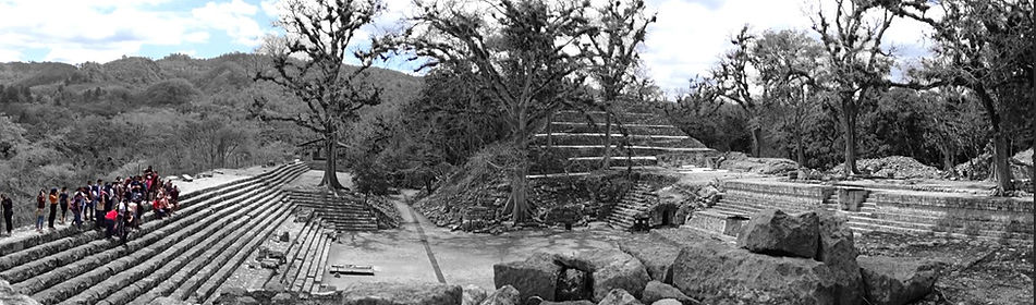
COPAN RUINS - HONDURAS
%20(1).png)

It is a region characterized by being part of the so-called Maya Classic Period, situated along a river edge in a floodplain, known as the Copan River at an altitude of 600 meters; during its peak, its population was estimated at 20,000 inhabitants, this during the 8th century. The area covers approximately 250 acres, consisting of an artificial platform that is protected by UNESCO as a World Heritage Site.
%20(1)%20(1).png)
In its past, it was characterized by being an economic center with regional impact, in which it played an important role in trade through products produced from Jade and Obsidian, which characterized the social classes of the period in the classical period.
The characteristics of the urban implantation: architectural and arts are present in the vast majority, which were not destroyed during the Copan River flood period. There are still structures, pyramids, a “pelota” games square and terraces built with local materials, the vast majority of which are limestone structures, whose location is characterized by an elevated plane allowing a vast view of the immediate surroundings.
It is important to highlight the existence of a vast record of existing temples and structures, which currently have a ceremonial center dating back to the 6th century, with more than 2,500 griffins present since the so-called Late Period, but which was fundamental in establishing the artistic characteristics through the ceramics and adornments present in its architecture, records that include sculptures in the temples and beautifully detailed and designed as records in the 19th century by the architect and explorer Catherwood.


UXMAL AND XKALUPOCOH / NOHPAT, IN THE PUUC REGION, IN THE YUCATÁN PENINSULA - MEXICO

.png)


The Puuc cultural region is located in the southern part of the state of Yucatán and the northern part of Campeche. The term "Puuc" in Yucatec Maya means "mountain" or "hill," indicating that this area is the most rugged in the Yucatán Peninsula. It includes two chains of hills, known as the Sierrita de Ticul and the Bolonchen hills, along with the Santa Elena Valley.
A key factor influencing the density of pre-Hispanic sites in the region was undoubtedly the large expanses of fertile land that facilitated agriculture. However, the term "Puuc" carries three connotations: geographic area, archaeological region, and architectural style.
The term "Puuc" denotes the archaeological region situated within the geographic area described above. Culturally, its boundaries in the southern region are not very precise, as they share characteristics with the architecture of Rio Bec and Chenes. Historically, the pre-Hispanic Mayas of Puuc reached their zenith during the period known as the Late Classic (600-1000 AD). It was during this phase that the architecture and its typological characteristics of this region emerged, spreading through this area to places such as Chichen Itza, Ek Balam, and Culuba.
Around 750 AD, the Classic Puuc typology encompassed the entire cultural region, extending towards the northwest of Yucatán, beyond the mountains. This extension of the area of influence was due to intense trade, both maritime and terrestrial. By the end of the 10th century, the Puuc culture began to decline; as a contributing factor to this decline, it is considered that conflict with the Putun groups, who first took over the trade networks and later settled in Chichen Itza, played a significant role.
Subsequently, they consolidated their power in northern Yucatán and expanded until they came into conflict with the inhabitants of the Puuc region, leading to the loss of their rulers. It is assumed that these settlements were abandoned, and only in specific cases were the settlements reclaimed by isolated groups, since in the Post-Classic era the region was largely depopulated.
A partir daí consolidaram seu poder no norte de Yucatán e o ampliaram até entrarem em conflito com os habitantes da região de Puuc, perdendo seus governantes; Supõe-se que estes assentamentos foram abandonados e apenas em casos particulares os assentamentos foram recuperados por grupos isolados, uma vez que na era pós-clássica a região estava maioritariamente despovoada.


IXIMCHÉ - GUATEMALA

.png)
.png)

Iximché became a crucial political, religious, and cultural center for the Kaqchikeles, who shared the region with other important Maya civilizations. The meaning of the name Iximché is: Ixim = Corn Chée = Tree. The Spanish translation would be Corn Tree or Ramón Tree.The Iximché site extends over approximately 18 hectares and has an architectural structure that includes courtyards, terraces, temples, and residential structures. Among the most notable structures is the Acropolis, a series of temples and plazas that served as both a ceremonial and administrative center. The Kaqchikeles held important religious ceremonies here, paying homage to their deities and rulers. Iximché also played a crucial role in the history of the Spanish conquest, as it was here that the conquistadors established alliances with some local indigenous groups in their conflict with the Kaqchikel and other Maya peoples. This archaeological site offers visitors a fascinating window into the history and culture of the Mayan civilizations that thrived in the region.
Iximché is an archaeological site of the Late Classic period, located in the western highlands of Guatemala, in the municipality of Tecpán Guatemala, in the department of Chimaltenango, approximately 3 km south of the seat of that municipality, at an altitude of 2,260 meters above sea level, on the slopes of Mount Ratzum. This fortification was called by the Mexicans Tecpán Cuauhtlimallán. From its founding in 1470 until its abandonment in 1524, it was the capital of the Kaqchikel kingdom, one of the Mayan civilizations, during the Postclassic period.
[ GRADUAÇÃO ]


[ INICIAÇÃO CIENTÍFICA ]

Revitalização de Zonas Arqueológicas: Parque Ecoturismo na Região de El Castillo, Tulum
Thais Daniela Gomes Paiva

As Estratégias de Desenvolvimento Econômico Frente as Mudanças Climáticas: o Caso de Copán Ruínas
Ana Carolina Peres Aguiar


bottom of page